Love the idea of walking out your door to a canyon trail in the morning and a riverside stroll at sunset? In Studio City, that lifestyle is real. If you are buying or selling near Fryman Canyon and the LA River, the setting can shape daily life and your property’s appeal. This guide shows you what matters most, how to position it, and what to check before you move. Let’s dive in.
Why Studio City’s setting sells
Studio City sits between hillside open space and linear river greenways, which means quick access to both views and flat paths. Fryman Canyon and Wilacre Park offer shaded trails and overlooks that feel worlds away yet sit minutes from Ventura Boulevard. Along the LA River, neighborhood greenways add artful places to walk or bike on mostly level terrain. Together, these amenities create a simple promise: more time outside with less time in the car.
Fryman Canyon essentials
Access and parking
Fryman Canyon Park spans about 122 acres with the principal trailhead at the Nancy Hoover Pohl Overlook on Mulholland. The overlook has a paved lot and an ADA‑friendly gateway into the park. On busy weekends, lots can fill, and some parking may spill onto nearby residential streets. Start with the official Fryman Canyon Park details and the Pohl Overlook page for current access notes.
Trail use and rules
The Betty B. Dearing Trail connects Fryman to Wilacre and beyond. Hikers, equestrians, and dogs on leash are allowed. Mountain biking is not permitted on the Dearing Trail. For up‑to‑date rules or closures, check the MRCA’s Fryman page.
What buyers notice
Typical routes from Mulholland offer roughly 1.5 to 3 miles with moderate elevation change and shaded canyon sections. Proximity brings daily convenience and potential views. It can also bring weekend activity near trailheads, so visit at peak times to understand the rhythm of the block.
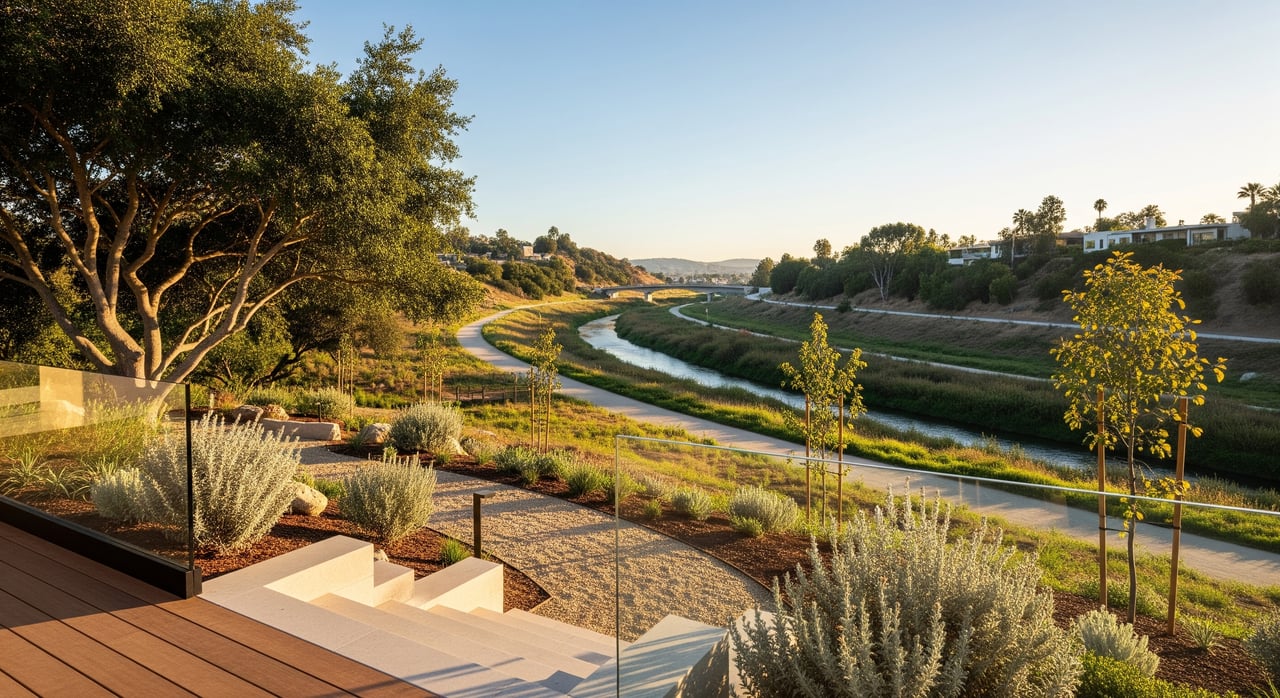
River greenways in Studio City
North Valleyheart Riverwalk
On the north bank, the North Valleyheart Riverwalk is a neighborhood linear park with art installations, seating, and multiple access points around Fulton, Ethel, and Coldwater. It is designed for strolling and lingering rather than high‑speed cycling. Learn more about the Riverwalk’s art and access from PBS SoCal’s overview.
LA River bikeway segments
On the south bank, the City opened a 0.5‑mile paved bikeway between Whitsett Avenue and Coldwater Canyon in 2019. Other short segments exist, but they are not yet continuous. New segments often include stormwater features and interpretive signage. See opening coverage of the Studio City segment from Streetsblog.
Connectivity today
The long‑term plan is a connected corridor across the Valley, but today you will still encounter gaps and street crossings. Multiple agencies are working in phases, and timelines depend on funding and engineering. For planning context on phased connections, see this regional program overview of greenway projects and water management goals here.
How the trails and river affect value
Studies consistently show parks and quality greenways can support nearby property values, with effect sizes that vary by city, park type, and distance. The key takeaway for Studio City is lifestyle: quick access to Fryman and Wilacre, plus the Riverwalk and bikeway segments, can be a meaningful differentiator for buyers who prioritize time outside. For a national summary of how parks contribute to value, see the Trust for Public Land’s analysis of the economic benefits of community green spaces.
A few moderating factors matter on the micro level. Immediate adjacency to a busy path can trade privacy for convenience. Trailhead blocks can see more weekend parking. Along the river, appearance and flood control functions influence appeal by location. Balance these realities with accurate disclosures and on‑site observation.
Hazard due diligence is essential near hillsides and waterways. The Fryman and Wilacre area sits within the wildland‑urban interface, so review the State Fire Marshal’s Fire Hazard Severity Zone guidance. For river‑adjacent parcels, flood insurance needs depend on FEMA mapping at the property level. Start with resources that point you to the FEMA Map Service Center through this flood zone and mapping guidance.
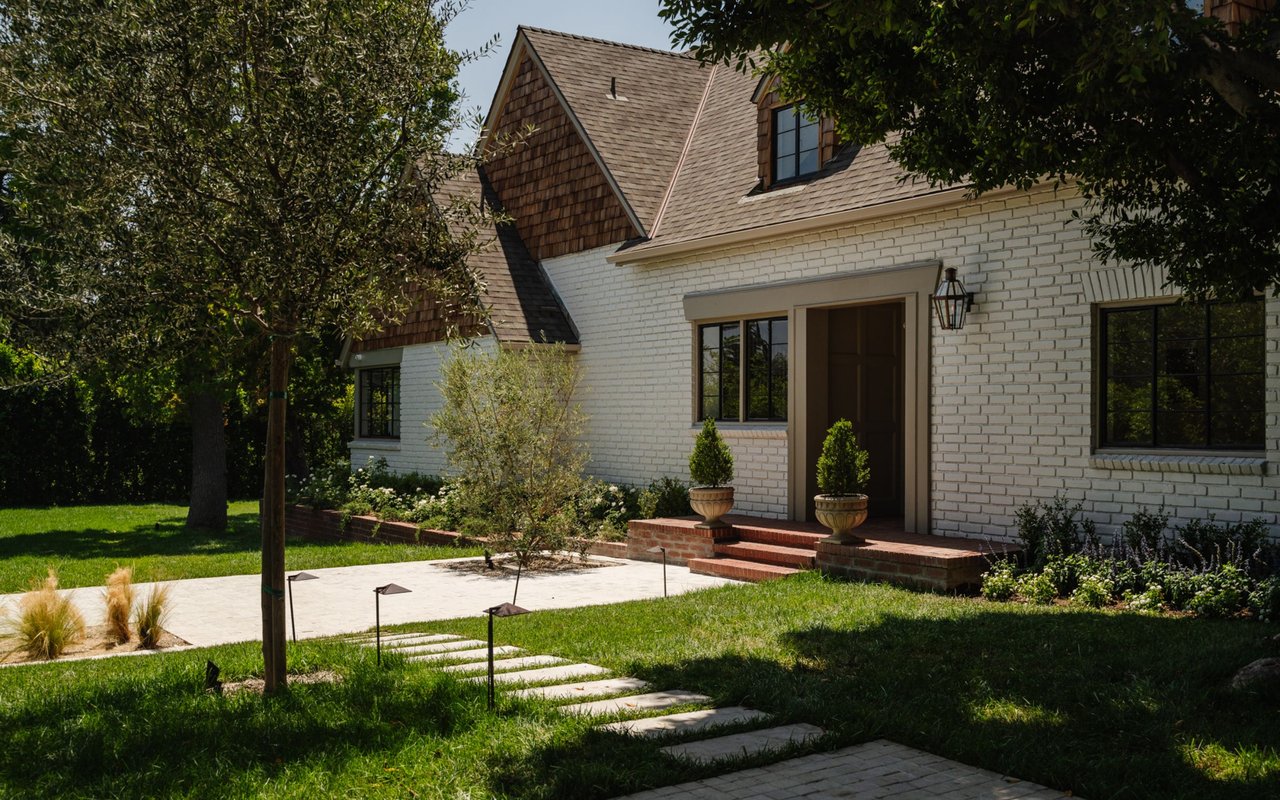
Seller playbook: showcase the setting
- Lead with lifestyle. Highlight distance to the Pohl Overlook trailhead, Wilacre Park’s lower access, and nearby Riverwalk entries. Link features to daily routines buyers can picture.
- Stage for the story. Create vignettes that nod to weekend hikes or evening river strolls. A mudroom hook, a bench by the door, or a shaded patio setup can sell the experience.
- Map the micro‑amenities. Provide a simple map with walking or driving minutes to trailheads and greenway entries, plus where to grab coffee on the way.
- Handle realities up front. Note typical weekend parking patterns and any on‑site mitigations like privacy fencing or landscaping. Buyers appreciate clarity.
- Package due diligence. If applicable, compile defensible‑space steps, vegetation management, and recent insurance notes. Include any floodplain determinations for peace of mind.
- Elevate visuals. Twilight exteriors, sunrise deck shots, and nearby trail imagery used appropriately can tie the home to its setting.
With design‑driven storytelling and production‑quality marketing, you can turn proximity to Fryman and the River into a premium positioning point.
Buyer checklist: pick the right block
- Walk it at different times. Visit mornings, afternoons, and a weekend peak to feel parking, noise, and foot traffic.
- Trace your routes. Test the drive or walk to the Pohl Overlook and Wilacre lots, then sample the North Valleyheart Riverwalk from your likely entry point.
- Verify rules and access. Confirm dog, equestrian, and trail use policies through MRCA’s Fryman page and check for any posted hours.
- Check wildfire maps. Use the State Fire Marshal’s FHSZ tools and ask about defensible‑space status.
- Confirm flood designation. Review property‑specific flood zones via resources that direct you to FEMA’s Map Service Center using this flood mapping guidance.
- Watch future plans. Partial greenways may become more connected in phases. Review recent openings and planned segments such as the 2019 Whitsett to Coldwater bikeway via Streetsblog.
When you are ready to position your Studio City home around its one‑of‑a‑kind setting, or to find a block that fits your lifestyle, connect with the SANDLER + HIRSCH GROUP for bespoke strategy, valuation, and design‑forward marketing.
FAQs
How close is Fryman Canyon to Studio City homes?
- Fryman’s principal trailhead sits at the Nancy Hoover Pohl Overlook on Mulholland, placing many Studio City blocks within a short drive or an uphill walk depending on the address.
What is the North Valleyheart Riverwalk like in Studio City?
- It is a north‑bank neighborhood greenway with public art, seating, and multiple access points, designed for strolling rather than a continuous high‑speed bike path.
Is there a continuous LA River bike path through Studio City?
- Not yet; segments exist, including a 0.5‑mile paved stretch from Whitsett to Coldwater opened in 2019, with more connections planned in phases.
Do trailheads create parking issues near homes?
- Trailheads and popular entries can draw weekend parking to nearby streets, so buyers should visit at peak times and sellers should disclose typical patterns.
Does living near the LA River require flood insurance?
- It depends on your parcel’s FEMA flood zone; check the property’s specific designation to determine insurance requirements.