Looking for a quiet stretch of green in Studio City without leaving the neighborhood? The LA River edges through town with pocket paths, public art, and short bikeable segments that feel like a reset from Ventura Boulevard. You want to know where to start, how to link sections, and what to expect along the way. This guide maps the best spots to walk and ride, plus how to connect them and what is coming next. Let’s dive in.
Top river paths
South-bank Valleyheart Greenway
This south-bank stretch runs around the Laurelgrove and Valleyheart area and is a local favorite for easy loops and dog walks. You will find decomposed-granite paths, ramps, and a relaxed vibe along the water. The Laurelgrove footbridge is a common starting point, and you can follow the greenway toward Whitsett. For a step-by-step overview, see the local walk guide for Studio City on TheLARiver.
Radford Art Walk
Near the Radford area by the studio lot, this mini linear park layers in public art, seating, and native landscaping. Look for the striking “Great Toad Gate” and other installations that give this segment a gallery feel outdoors. It is popular with walkers and dog owners who want a short, scenic break. Get a preview of the art along the south bank from PBS SoCal’s feature.
North Valleyheart Riverwalk
On the north bank, parallel to parts of Ventura Boulevard, this formal Riverwalk offers gates and ramps with documented access near Fulton, Ethel, and Coldwater Canyon. Expect pedestrian-oriented surfaces, benches, and public art like the Rattlesnake Wall and Steelhead Trout mosaic. It is designed mainly for walking. Learn more about access points on the North Valleyheart Riverwalk page.
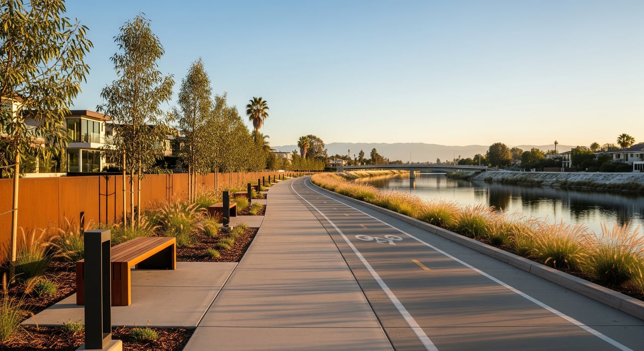
Whitsett to Coldwater bikeway
In 2019 the city opened a paved multi-use segment linking Whitsett Avenue to Coldwater Canyon Avenue, roughly a half mile. It is smooth and family friendly for easy spins or stroller walks. The catch is connectivity. Segments end at bridges and surface streets, so you will make short on-street connections between greenway pieces. See the opening coverage and context from Streetsblog L.A..
Access and parking
Transit is straightforward. The Universal City stop on the B Line connects with Ventura Boulevard buses, which put you near several access points around Valleyheart and Laurelgrove. A local walk overview with access notes is available on TheLARiver’s Studio City guide.
Street parking is common on residential blocks near Valleyheart and around Laurelgrove. Always check signs and time limits. For longer rides, many cyclists stage near Ventura Boulevard or at neighborhood parks.
Surfaces, rules, safety
Surfaces
Expect a mix of paved asphalt on newer bike segments and compacted or decomposed-granite paths on walking greenways. Surfaces can change within short distances, so ride and walk with care when transitioning between segments. Streetsblog’s coverage of the 2019 segment notes typical surface conditions for the area here.
Rules and hours
River-adjacent segments generally follow park-style hours, typically sunrise to sunset. Dogs are commonly allowed on-leash. Some LA River reaches operate as designated recreation zones with seasonal schedules and ranger enforcement. Always follow posted signs. See an overview of recreation-zone operations from MRCA.
Safety and lighting
Plan for daylight outings. Lighting is limited in many stretches, and path ends can appear suddenly near bridges or street crossings. Be alert where equestrian use is posted in nearby areas of the valley. Streetsblog’s reporting highlights the need to slow at segment ends and crossings here.
Amenities
Expect public art, benches, native plantings, and occasional bike racks. Restrooms and water are limited on the Studio City segments. Larger parks and regional river zones offer more full-service amenities. You can explore city-listed river sections on the LA River Explore page.
Connect to longer routes
If you want to extend your outing, you have great nearby options. The Tujunga Wash Greenway features the landmark Great Wall of Los Angeles mural and a continuous path that is easy to fold into a valley loop. Read more on the Tujunga Wash Greenway.
For longer bike mileage, the G Line Bikeway runs east-west across the valley and ties into North Hollywood and Woodland Hills. Get the overview on the G Line Bikeway. You can also browse city-listed river areas like Sepulveda Basin and Elysian Valley for bigger, more continuous rides on the LA River Explore page. Expect short on-street links from Studio City segments to reach these corridors.
What is changing
Studio City’s river paths are part of a larger push to connect a continuous LA River Greenway. The city and county are advancing gap-closure segments through environmental review, design, and public meetings. You can track active actions, including Phase IV bikeway items, via the City Council file system. See recent records for LA River path work in Council File 23-0722.
Funding comes from a mix of city, county, Metro, and state sources. Some mobility projects are being prioritized in the run-up to the 2028 Olympics, although timelines vary by project and approvals.
Loops and quick tips
- 30-minute art walk: Start at the Laurelgrove footbridge, explore the south-bank Valleyheart Greenway, include the Radford Art Walk, then loop back.
- Family-friendly bike: Ride the Whitsett to Coldwater segment out and back. Add a calm neighborhood detour if you want a bit more mileage.
- Easy afternoon stroll: Enter the North Valleyheart Riverwalk at Ethel or Coldwater and enjoy the pedestrian path and public art.
- Pro tip: Expect gaps between segments. Plan short on-street links and return routes in advance.
Studio City’s river edges are small but memorable. When you want fresh air, public art, and a different view of the valley, these paths deliver a simple reset close to home. If you are exploring neighborhoods that fit the lifestyle you want, connect with the SANDLER + HIRSCH GROUP for clear, design-forward guidance across Greater Los Angeles.
FAQs
Can you bike the LA River continuously in Studio City?
- Not yet. Several short segments exist, and you will make brief on-street connections to link them together, as noted by Streetsblog L.A..
Where can you start a Studio City river walk?
- The Laurelgrove footbridge and Valleyheart access points are common starts, outlined in TheLARiver Studio City guide.
Are dogs allowed on these paths?
- Dogs are commonly permitted on-leash on river greenways and adjacent parks. Follow posted rules and hours. See recreation-zone management from MRCA.
What time of day is best for a visit?
- Daylight hours are recommended since lighting is limited and many areas follow sunrise-to-sunset schedules. Recreation zones also operate seasonally, per MRCA.
Are there restrooms or water on the Studio City segments?
- Limited. Most Studio City stretches are pocket greenways with art and seating rather than full-service facilities. Larger river parks listed on the city’s Explore the LA River map may offer more amenities.
How do you link to longer rides nearby?
- Use short surface-street links to reach the G Line Bikeway or the Tujunga Wash Greenway, then loop back through Studio City.